
Everest is the main peak of the Himalayas. It is 8,848 meters above sea level and is the highest peak on Earth.
It is located in the eastern section of the China-Nepal border. The north slope is in the county of Dingmu in the Tibet Autonomous Region of the People's Republic of China and the southern slope is in the Kingdom of Nepal. Tibetan is called "Qomolangma," which means the third goddess.
The Mount Qomolangma is a massive tower of gold. The mighty terrain is extremely dangerous and the environment is extremely complex. The snow line height is 5800-6200 meters on the north slope and 5500-6100 meters on the south slope. Three steep walls (north wall, east wall and southwest wall) are sandwiched between the northeast ridge, southeast ridge and west ridge. Between these ridges and cliffs, there are 548 continental glaciers with a total area of ​​1457.07 square kilometers. There are 15 mountain glaciers with an area of ​​more than 10 square kilometers, and the largest velvet glacier is 26 kilometers long. The supply of glaciers mainly depends on the formation of snowpack metamorphism in the two major precipitation belts of the Indian Ocean monsoon zone. The glacier is full of ice-towered forests, and there are up to several tens of meters of ice cliffs and step-by-step traps of light and dark ice cracks, as well as dangerous ice avalanche.
Everest is not only magnificent, but also magnificent. In the range of 20 kilometers around it, the peaks are numerous and there are numerous mountains and rivers. There are more than 40 peaks above 7000 meters above sea level. The famous “Luozi Peak†(8516 meters above sea level, the fourth highest peak in the world) and the 7589 meters above sea level are the famous peaks in the south and the horses in the east. Karoo Peak (8,463 meters above sea level, the fifth highest point in the world), 3 kilometers to the north is Zhangzifeng at an altitude of 7543 meters, and the west is Nuzi Peak (7855 meters) and Pemori Peak (7145 meters). At the periphery of these giant peaks, there are still some world-class peaks that must be far apart and form the peaks and peaks of the peaks.
The climate of the peaks in the Everest region and its vicinity is complex and changeable. Even within a day, it is often unpredictable, not to mention the tumultuous changes that occur during the whole year. In general, the rainy season starts from early June to mid-September, and the intense southeast monsoon causes frequent heavy rain, clouds and fog, and ice and snow are raging at the impermanent and bad weather. From mid-November to mid-February, temperatures reach -60°C and average temperatures range from -40°C to -50°C. The maximum wind speed can reach 90 m/s. From early March to the end of May, it is the spring in which the wind season transitions to the rainy season. From the beginning of September to the end of October, the rainy season transitions to the autumn of the wind season. During this period, there may be better weather and it is the best season for climbing.
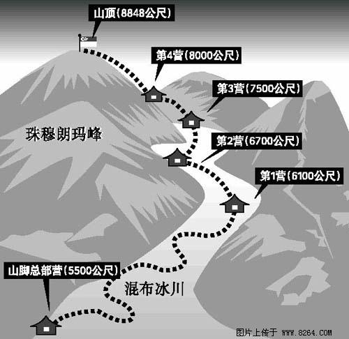
As early as the early 19th century, Everest became a place that mountaineers and scientists in the world had longed for. However, it was not until 1953 that British Edmund, Hillary, and Denzeng set a record for their first success. By the end of 1990, there were 53 teams and 267 people in 26 countries around the world enjoying the reputation of being at the top of the world. Through their own efforts, they discovered and created 11 mountaineering routes. (Picture transferred from Lianhe Zaobao)
Rocking Horse,Ride On Toy,Wooden Toy
Aomiao Inflatable Co., Ltd. , http://www.gz-toys.com