1. North side:
From the town of Lijiang in the north via the Qiaotou town, through the Tiger Leaping Gorge to the village of Haba, 2300 meters above sea level. Need to rent a car, poor road conditions, may be broken during the rainy season (a section of Tiger Leaping Gorge). The journey is about 5-6 hours. You can also go straight north from Lijiang County town and you will arrive at Haba Village after crossing the Jinsha River.
Approximately 15 km south of Haba village on the mountain road, you can reach the base camp on the north slope, 4000 meters above sea level. This section of the journey needs to go through the virgin forest. It is easier to get lost and requires a local guide to take the route. The journey takes 6-8 hours.
2. On the west side: From the north of Qiaotou Town, passing Pingpingzi, arrived at the base of the Kaohsiung branch, with an elevation of 4,000 meters.
The four routes introduced basically overlap at 5300 or more. It should be noted that these four routes have a strong seasonality.
Xipo Traditional Route
First route in 1995. Climb from the west and finally cut the northwestern ridge. (not visible in the picture)
North Slope Northwest Route
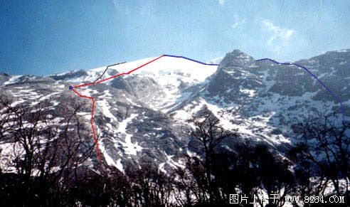
Going up the valley on the north side of the peak, and advancing along the valley to the right slope, this will be the most difficult part of the whole journey. The gravel slope with a small slope should pay attention to the rolling stone. After reaching the ridge, we climb up the ridge and build C1 near the snow line (4900). Then we can climb along this ridge. This route has a long journey, and it will be very difficult to advance along the valley bottom when there is severe snowfall in winter (the dense rhododendron bushes hide under the deep snow). The route is clear and not easy to get lost. There have been several times along this route to top the record. (blue line in the picture)
The northeast ridge course along the summit
On the north side of the valley, the big stone slab on the left side begins to climb. On the platform (4500) at the end of the big stone slab, C1 can be built. This platform cuts the northeast ridge to the upper left (steep broken, there are rolling stones, and many people go through recommended road construction). Go straight up the peak along the ridge. This route was heard during the summer from BC-C1 Da Slate. There will be running water and it cannot be climbed. The distance above the snow line is very long, and the height difference (more than 800 meters) requires more physical strength and sufficient time. For this time, the new team was opened for the first time and it was not at the top. (brown line in the picture)
North Wall Route
The BC-4500 meters is on the same route as the Eastern Ridge, and ABC can be built on 4,500 platforms. This leads to the upper right of the valley to the top of the valley on the north side of the peak (steep broken, there will be a rolling stone, many people recommended road construction), the snow line platform (4900) built C1. This will go straight to the top. The route is the shortest, the route is not clear, and it is easy to go down the valley when going down. For this time, the Cowin team opened its doors and did not climb to the top. (red line in the figure)
Drawstring Backpack,Best Drawstring Backpack,Leather Drawstring Backpack,Canvas Drawstring Backpack
Ningbo Happiness Stationery Industrial & Trading Co Ltd , https://www.bagshappiness.com